- BY COLLECTION:
- >
- Mandala & Métis
- >
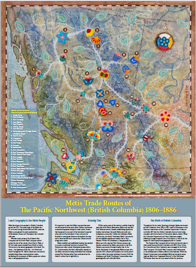
- "Métis Trade Routes of the Pacific Northwest (British Columbia) 1806-1886"
"Métis Trade Routes of the Pacific Northwest (British Columbia) 1806-1886"
by Kristi Bridgeman and Lisa Shepherd
This map shows the trade routes and historical landing places of Métis people in BC, indicated by “mousetracks” and flower beadwork. Each flower is numbered and the legend tells the name of the relating fort or landing place of significant Métis interest. The four directions are indicated in the Michif language. The land geography and its relationship to Métis people, kinship ties and the birth of British Columbia are described, making it an excellent learning tool for the home, office or classroom. To read about this artist collaboration, see this web page.
*ART MAP (POSTER): 22"x30". Printed locally, 100% recycled FSC-certified paper.
Shipping: Via Canada Post. Allow two or more weeks for delivery for within Canada, longer for international. Prices calculated on check-out.


